SOTA Activation of Mt Herman, W0C/FR-063, 19 June 2023
I had the day off for Juneteenth (19 June) so I had planned on a relatively easy activation of Mt Herman (W0C/FR-063), which was my very first SOTA activation back on 3 July 2021. Mt Herman is a 4-point summit located just west of Monument Colorado, about halfway between Denver and Colorado Springs, just off of I-25.
Unfortunately, the "easy" part turned out to be not so easy. On my previous outing, we were able to drive up the Mt Herman road all the way to the south trailhead, and it was a relatively easy hike to the summit about an hour or so.
This time around, I discovered that Mt Herman road is closed to all motorized vehicles about 3 miles from the trailhead due to a rock slide and a bit of the road that washed away with recent rain. I consulted the topo map and discovered another route, up the North side of the mountain, and decided to give that a try.
Unfortunately, the North route, while much more direct, is very steep and not all that well marked. Many sections of loose dirt/gravel further hampered my progress, along with one section, about 1/10 of a mile, where a nearby stream had overtaken its banks and turned the trail into a stream. So slippery, muddy going. It wound up taking me 2.5 strenuous hours to make it to the summit and I nearly turned around several times.
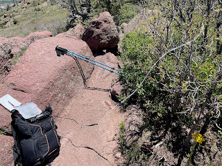
Fortunately, it was an absolutely gorgeous day up on the summit. I set up my IC-705 with a 2-meter rollup J-Pole, broke out my lunch, self spotted using the SOTA Goat app (there is great cell coverage on Herman due to its proximity to Monument and I-25) and started calling CQ using 10 watts. I wound up with 9 QSOs, including 2 S2S (summit-to-summit), with the longest being about 55 miles away in Thornton CO. I had planned on doing a 20-meter HF activation with my Alexloop mag loop antenna, but I was running out of time as I had to be back in Denver by 5pm.
I wasn't relishing the idea of going back down the northern route, which a local at the top informed me is known as "ankle breaker", so I made the decision to take the easier southern route back down and make the additional 3-mile walk down the road to my parking spot. I also wanted to examine the condition of the road and see the rockslide for myself. It was an easy, albeit very long hike, and with temps in the low 90s I emptied my hydration pack about halfway down the road and began to worry about dehydration a bit.
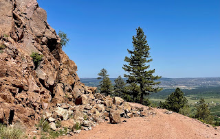
There are two bad spots on the road. The first, which is just short of the Mt Herman trailhead, is a pretty serious washout which would be a little dicey for a vehicle to navigate. It also looks like it could be prone to further damage and collapse if vehicles were to drive over it. The second spot, about a mile down the road, was the site of a decent rock slide with good-sized boulders littering the road. With a little work moving boulders a high clearance vehicle could probably make it past this section, but I'm sure they closed the road because of the danger of further rockslides in the area. This was not the only area where I could see that boulders had come down on to the road.
So, what I thought would be an easy ~3 hour, 2 mile hike turned into about 5 hours with some pretty scary moments heading up the north side. Unless you're a very experienced hiker in good shape, I would recommend avoiding Mt Herman until they get the road open again.


Comments
Post a Comment